Caloris Planitia: Difference between revisions
CSV import Tags: mobile edit mobile web edit |
CSV import |
||
| Line 29: | Line 29: | ||
{{Solar System}} | {{Solar System}} | ||
{{Geology-stub}} | {{Geology-stub}} | ||
<gallery> | |||
File:MESSENGER_first_photo_of_unseen_side_of_mercury_cropped_to_Caloris.jpg|MESSENGER first photo of unseen side of Mercury cropped to Caloris | |||
File:Caloris_Basin_comparison.jpg|Caloris Basin comparison | |||
File:Mercury_weird_terrain.jpg|Mercury weird terrain | |||
File:Mercury's_'Weird_Terrain'.jpg|Mercury's 'Weird Terrain' | |||
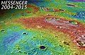
File:Caloris_Basin_topography_JMARS_Colorized_Shade_2km.jpg|Caloris Basin topography JMARS Colorized Shade 2km | |||
File:Caloris_basin_labeled.png|Caloris basin labeled | |||
File:Spider_crater_on_planet_mercury.jpg|Spider crater on planet Mercury | |||
File:PIA19421-Mercury-Craters-MunchSanderPoe-20150416.jpg|Mercury Craters Munch Sander Poe | |||
File:PIA19450-PlanetMercury-CalorisBasin-20150501.jpg|Planet Mercury Caloris Basin | |||
</gallery> | |||
Revision as of 12:04, 18 February 2025
Caloris Planitia is a large impact crater located in the Mercury's solar hemisphere, notable for being one of the largest impact basins in the Solar System. Discovered during the Mariner 10 mission in 1974, Caloris Planitia has since been a focal point of planetary science research, particularly in the study of planetary geology and impact events. The basin's name, which means "hot plain" in Latin, reflects its position within Mercury's surface, where temperatures can reach extreme highs due to the planet's proximity to the Sun.
Formation
Caloris Planitia is believed to have formed approximately 3.9 billion years ago during the Late Heavy Bombardment, a period characterized by frequent and massive impact events throughout the inner Solar System. The impact that created Caloris Planitia was so powerful that it caused lava flows on the opposite side of the planet and generated a concentric series of mountains and valleys around the basin.
Geology
The basin spans about 1,550 kilometers in diameter and is surrounded by a ring of mountains known as the Caloris Montes. The interior of Caloris Planitia is marked by a series of geological features, including volcanic plains, fractures, and craters that have been superimposed on the original basin floor. These features suggest a complex geological history involving volcanic activity and tectonic movements post-impact.
Smooth plains found within the basin are indicative of extensive volcanic activity, which likely occurred shortly after the basin's formation. These plains are interspersed with more rugged terrain, including chaotic terrain that is thought to have formed as a result of seismic activity following the impact.
Exploration
Following its discovery by Mariner 10, Caloris Planitia has been further studied by subsequent missions, most notably by the MESSENGER spacecraft, which orbited Mercury between 2011 and 2015. MESSENGER provided detailed images and data on the basin's geology, revealing insights into its composition, structure, and the processes that have shaped it over billions of years.
Scientific Importance
Caloris Planitia serves as a key site for understanding the impact processes that have shaped the terrestrial planets. The basin's size and the extent of its associated geological features provide valuable information on the dynamics of impact events, as well as the geological evolution of Mercury. Studies of Caloris Planitia also contribute to broader questions in planetary science, such as the history of volcanic activity and tectonics on rocky planets.
See Also
| Mercury | ||||||
|---|---|---|---|---|---|---|
This Mercury-related article is a stub. You can help WikiMD by expanding it.
|
Script error: The function "with columns" does not exist.

-
 MESSENGER first photo of unseen side of Mercury cropped to Caloris
 -
 Caloris Basin comparison
 -
 Mercury weird terrain
 -
 Mercury's 'Weird Terrain'
 -
 Caloris Basin topography JMARS Colorized Shade 2km
 -
 Caloris basin labeled
 -
 Spider crater on planet Mercury
 -
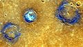 Mercury Craters Munch Sander Poe
 -
 Planet Mercury Caloris Basin


