Kent: Difference between revisions
CSV import Tag: Manual revert |
CSV import |
||
| Line 28: | Line 28: | ||
{{stub}} | {{stub}} | ||
<gallery> | |||
File:Kent_UK_locator_map_2010.svg|Kent UK locator map 2010 | |||
File:Kent_-_British_Isles.svg|Kent - British Isles | |||
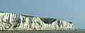
File:White_Cliffs_of_Dover,_Kent.jpg|White Cliffs of Dover, Kent | |||
File:Saint_Thomas_Becket_(Samuel_Caldwell,_1919)_crop.jpg|Saint Thomas Becket (Samuel Caldwell, 1919) | |||
File:Rochester_Castle_Keep_and_Bailey_0038stcpcropped.png|Rochester Castle Keep and Bailey | |||
File:Kent_numbered_districts.svg|Kent numbered districts | |||
File:Anglo-Saxon_Chronicle_-_kentland_(British_Library_Cotton_MS_Tiberius_A_VI,_folio_4r).jpg|Anglo-Saxon Chronicle - kentland | |||
File:FlagOfKent.svg|Flag of Kent | |||
File:HistorieKent1576.jpg|Historie Kent 1576 | |||
File:Cantium_southsexia_surria_meddlesexia_Atlas.jpg|Cantium southsexia surria meddlesexia Atlas | |||
File:White_cliffs_of_dover_09_2004.jpg|White cliffs of Dover 09 2004 | |||
File:France_manche_vue_dover.JPG|France manche vue dover | |||
</gallery> | |||
Latest revision as of 21:17, 23 February 2025
Kent is a county in South East England and one of the home counties. It borders Greater London to the north-west, Surrey to the west, and East Sussex to the south-west. The county also shares borders with Essex along the estuary of the River Thames (connected by land via High Speed 1 and the Dartford Crossing), and with the French department of Pas-de-Calais through the Channel Tunnel. The county town is Maidstone.
Kent was originally inhabited by the Celtic tribe, the Cantiaci in the first century BC. Following the Roman conquest of Britain, the area was known as Cantium, a name derived from the Cantiaci tribe. The Romans fortified the old capital of the Cantiaci, Durovernum Cantiacorum, which was later renamed Canterbury by the Anglo-Saxons.
Kent is known as the "Garden of England" due to its abundance of orchards and hop gardens. The county has a diverse economy, with significant contributions from the retail, construction, and tourism sectors. It is also home to the Port of Dover, the UK's busiest passenger port.
History[edit]
Kent's location between London and continental Europe has led to it being in the front line of several conflicts, including the Battle of Britain during World War II. East Kent was known as Hell Fire Corner during the conflict. England has relied on the county's ports to provide warships through much of its history; the Cinque Ports in the 12th–14th centuries and Chatham Dockyard in the 16th–20th centuries were of particular importance.
Geography[edit]
Kent is in the southeastern corner of England. It borders the River Thames and the North Sea to the north, and the Strait of Dover and the English Channel to the south. France is 34 kilometres (21 mi) across the Strait.
Economy[edit]
Kent's economy is greatly diversified. Haulage, logistics, and tourism are major industries. In northwest Kent, industries include extraction of aggregate building materials, printing and scientific research. Coal mining has also played its part in Kent's industrial heritage.
Culture[edit]
Kent is the main area for hazelnut production in the UK. However, in recent years there has been a significant drop in agriculture, and industry and services are increasing their utilisation of the area. This is illustrated by the demographic pattern of wide parts of Kent, particularly along the north coast.
See also[edit]
 | |
|---|---|
|
|
 |
-
 Kent UK locator map 2010
 -
 Kent - British Isles
 -
 White Cliffs of Dover, Kent
 -
 Saint Thomas Becket (Samuel Caldwell, 1919)
 -
 Rochester Castle Keep and Bailey
 -
 Kent numbered districts
 -
 Anglo-Saxon Chronicle - kentland
 -
 Flag of Kent
 -
 Historie Kent 1576
 -
 Cantium southsexia surria meddlesexia Atlas
 -
 White cliffs of Dover 09 2004
 -
 France manche vue dover


_crop.jpg)


