Rakhine State: Difference between revisions
CSV import |
CSV import |
||
| Line 25: | Line 25: | ||
{{Myanmar-geo-stub}} | {{Myanmar-geo-stub}} | ||
{{food-stub}} | {{food-stub}} | ||
<gallery> | |||
File:Silver coin of king Nitichandra Arakan Brahmi legend NITI in front Shrivatasa symbol reverse 8th century CE.jpg|Silver coin of king Nitichandra Arakan Brahmi legend NITI in front Shrivatasa symbol reverse 8th century CE | |||
File:1555-56 CE World Map.PNG|1555-56 CE World Map | |||
File:Laung Bwann Brauk pagoda.jpg|Laung Bwann Brauk pagoda | |||
File:Rohingya refugees entering Bangladesh after being driven out of Myanmar, 2017.JPG|Rohingya refugees entering Bangladesh after being driven out of Myanmar, 2017 | |||
File:Jake Taw Village from Above.jpg|Jake Taw Village from Above | |||
File:Map of Rakhine (Arakan) State in Myanmar.png|Map of Rakhine (Arakan) State in Myanmar | |||
File:Clock tower, main road and central market 14.jpg|Clock tower, main road and central market | |||
File:Hilltop Buddha at the southern end of Jade Taw bay 29.jpg|Hilltop Buddha at the southern end of Jade Taw bay | |||
File:Haridaung-Mrauk U-Aussicht-12-Pagoden im Dunst-gje.jpg|Haridaung-Mrauk U Aussicht 12 Pagoden im Dunst | |||
File:Kaladan Multi-Modal Transit Transport Project.svg|Kaladan Multi-Modal Transit Transport Project | |||
</gallery> | |||
Latest revision as of 06:05, 3 March 2025
Rakhine State (also known as Arakan) is a coastal state in Myanmar, located in the western part of the country. It is bordered by Chin State to the north, Magway Region, Bago Region and Ayeyarwady Region to the east, the Bay of Bengal to the west, and the Chittagong Division of Bangladesh to the northwest.
History[edit]
The history of Rakhine State can be traced back to the Indian subcontinent. The region was a prominent trading hub and was known for its strategic location along the Silk Road. The area was originally known as the Kingdom of Arakan before it was annexed by the British Empire in the 19th century.
Geography[edit]
Rakhine State is characterized by its rugged terrain, which includes the Arakan Mountains that separate it from central Myanmar. The state's coastline along the Bay of Bengal is dotted with numerous islands, the largest of which is Ramree Island.
Demographics[edit]
The population of Rakhine State is diverse, with the majority being the Rakhine people, who are predominantly Buddhist. There are also significant populations of Chin people, Kaman people, and Rohingya people, the latter of which are predominantly Muslim.
Economy[edit]
The economy of Rakhine State is primarily based on agriculture, with rice being the main crop. The state is also known for its fishing industry, and for the production of rubber and salt.
Culture[edit]
Rakhine culture is a blend of local traditions and influences from neighbouring regions. The state is known for its unique forms of music, dance, and art, as well as its distinctive cuisine.
See also[edit]


-
 Silver coin of king Nitichandra Arakan Brahmi legend NITI in front Shrivatasa symbol reverse 8th century CE
 -
 1555-56 CE World Map
 -
 Laung Bwann Brauk pagoda
 -
 Rohingya refugees entering Bangladesh after being driven out of Myanmar, 2017
 -
 Jake Taw Village from Above
 -
 Map of Rakhine (Arakan) State in Myanmar
 -
 Clock tower, main road and central market
 -
 Hilltop Buddha at the southern end of Jade Taw bay
 -
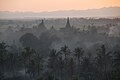 Haridaung-Mrauk U Aussicht 12 Pagoden im Dunst
 -
 Kaladan Multi-Modal Transit Transport Project


_State_in_Myanmar.png)


