British Indian Ocean Territory: Difference between revisions
CSV import Tags: mobile edit mobile web edit |
CSV import |
||
| Line 29: | Line 29: | ||
[[Category:British Overseas Territories]] | [[Category:British Overseas Territories]] | ||
{{geo-stub}} | {{geo-stub}} | ||
<gallery> | |||
File:U.S. Navy Band - God Save the Queen.oga|U.S. Navy Band - God Save the Queen | |||
File:Coat of arms of the British Indian Ocean Territory.svg|Coat of arms of the British Indian Ocean Territory | |||
File:Diplomatic Cable signed by D.A. Greenhill, dated August 24, 1966.jpg|Diplomatic Cable signed by D.A. Greenhill, dated August 24, 1966 | |||
File:Diegogarcia.jpg|Diego Garcia | |||
File:King Charles III (July 2023).jpg|King Charles III (July 2023) | |||
File:DG Ariel Plantation.jpg|DG Ariel Plantation | |||
File:SeychellesBIOT1970.jpg|Seychelles BIOT 1970 | |||
File:Biot-map.png|Biot map | |||
File:Terminal BIOT.jpg|Terminal BIOT | |||
File:Salomons Atoll in the Chagos.jpg|Salomons Atoll in the Chagos | |||
</gallery> | |||
Latest revision as of 05:54, 3 March 2025
British Indian Ocean Territory (BIOT) is a British Overseas Territory located in the Indian Ocean, halfway between Tanzania and Indonesia. The territory comprises the seven Atolls of the Chagos Archipelago with over 1,000 individual islands – many very small – amounting to a total land area of 60 square kilometers. The largest and most well-known island is Diego Garcia, which hosts a major United States Navy base.
History[edit]
The Chagos Archipelago was discovered by Portuguese explorers in the early 16th century. It came under French control in the 18th century before being ceded to the United Kingdom in 1814 under the Treaty of Paris. In 1965, three years prior to the independence of Mauritius, the UK detached the Chagos Archipelago from Mauritius to form the British Indian Ocean Territory. The creation of BIOT was primarily for strategic reasons, to allow the UK and the US to jointly operate a military base on Diego Garcia.
The establishment of the military base involved the controversial removal of around 2,000 Chagossians, the indigenous people of the islands, between 1967 and 1973. The Chagossians have since fought for the right to return, a subject of ongoing legal and diplomatic disputes.
Geography[edit]
The British Indian Ocean Territory is located around the equator in the central Indian Ocean. It is characterized by coral atolls and islands, with Diego Garcia being the largest and most significant due to its strategic military importance. The territory's exclusive economic zone covers approximately 640,000 square kilometers of ocean.
Biodiversity[edit]
Despite its small land area, BIOT has a rich biodiversity, including a variety of endemic species. The surrounding waters are home to healthy coral reefs, which support a diverse range of marine life, including several endangered species. The territory has been designated a marine reserve to protect its unique ecosystem.
Governance[edit]
As a British Overseas Territory, the British Indian Ocean Territory does not have its own permanent population. The UK government administers it through a Commissioner, based in London. The local laws are based on the British legal system, although adapted to the specific needs of the territory.
Economy[edit]
The economy of the British Indian Ocean Territory is limited due to its small size and the absence of a permanent civilian population. The presence of the military base on Diego Garcia is the primary economic activity, providing employment for military and civilian personnel, including contractors from Mauritius and the Philippines.
Controversies[edit]
The most significant controversy surrounding the British Indian Ocean Territory is the displacement of the Chagossians and their ongoing struggle for the right to return. Additionally, the environmental impact of the military base on Diego Garcia has been a subject of concern among environmentalists.
See Also[edit]

-
 U.S. Navy Band - God Save the Queen
 -
 Coat of arms of the British Indian Ocean Territory
 -
 Diplomatic Cable signed by D.A. Greenhill, dated August 24, 1966
 -
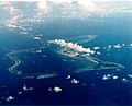 Diego Garcia
 -
 King Charles III (July 2023)
 -
 DG Ariel Plantation
 -
 Seychelles BIOT 1970
 -
 Biot map
 -
 Terminal BIOT
 -
 Salomons Atoll in the Chagos


.jpg)


