Kriging: Difference between revisions
CSV import |
CSV import |
||
| Line 39: | Line 39: | ||
[[Category:Geostatistics]] | [[Category:Geostatistics]] | ||
{{statistics-stub}} | {{statistics-stub}} | ||
<gallery> | |||
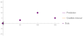
File:Example_of_kriging_interpolation_in_1D.png|Example of kriging interpolation in 1D | |||
File:Gaussianprocess.gif|Gaussian process | |||
File:Syncline_and_anticline.jpg|Syncline and anticline | |||
</gallery> | |||
Latest revision as of 01:53, 18 February 2025
Kriging is a method of interpolation used in the field of mathematical statistics, specifically in the area of spatial statistics. Named after South African mining engineer Dan Krige, Kriging is a technique that predicts the value of a variable at an unobserved location from observations of the variable at nearby locations.
History[edit]
Kriging was developed in the 1950s by Dan Krige, who sought to predict the distribution of gold based on samples from a few boreholes. The method was later generalized by the French mathematician Georges Matheron, who is considered the founder of the theory of spatial statistics.
Methodology[edit]
Kriging is based on statistical models that include a stochastic or random component. The method is unique in that it provides an estimate of the error of the prediction, which is based on the statistical properties of the data.
The basic idea of Kriging is to predict the value of a variable at a certain location by a weighted average of the values available at the surrounding locations. The weights are chosen to minimize the variance of the prediction error.
Types of Kriging[edit]
There are several types of Kriging, including:
- Simple Kriging: Assumes a known, constant mean value across the entire field.
- Ordinary Kriging: Assumes a constant but unknown mean value.
- Universal Kriging: Assumes a known, variable mean value.
- Indicator Kriging: A non-parametric method that transforms the data into binary indicators.
- Co-Kriging: Uses information from correlated variables to improve the prediction.
Applications[edit]
Kriging has been widely used in geostatistics and environmental statistics. It is commonly used in the mining industry to estimate the amount and spread of minerals. In environmental science, it is used to predict pollution levels at unobserved locations. Kriging is also used in meteorology to interpolate temperature and rainfall data, and in real estate to predict property values.
See also[edit]
References[edit]
<references />

This article is a statistics-related stub. You can help WikiMD by expanding it!
-
 Example of kriging interpolation in 1D
 -
 Gaussian process
 -
 Syncline and anticline


