File:USMajorityMinorityStates.png
From WikiMD's medical encyclopedia
Size of this preview: 800 × 506 pixels. Other resolutions: 320 × 203 pixels | 640 × 405 pixels | 1,024 × 648 pixels | 1,280 × 810 pixels | 1,934 × 1,224 pixels.
Original file (1,934 × 1,224 pixels, file size: 118 KB, MIME type: image/png)
Summary
| Description |
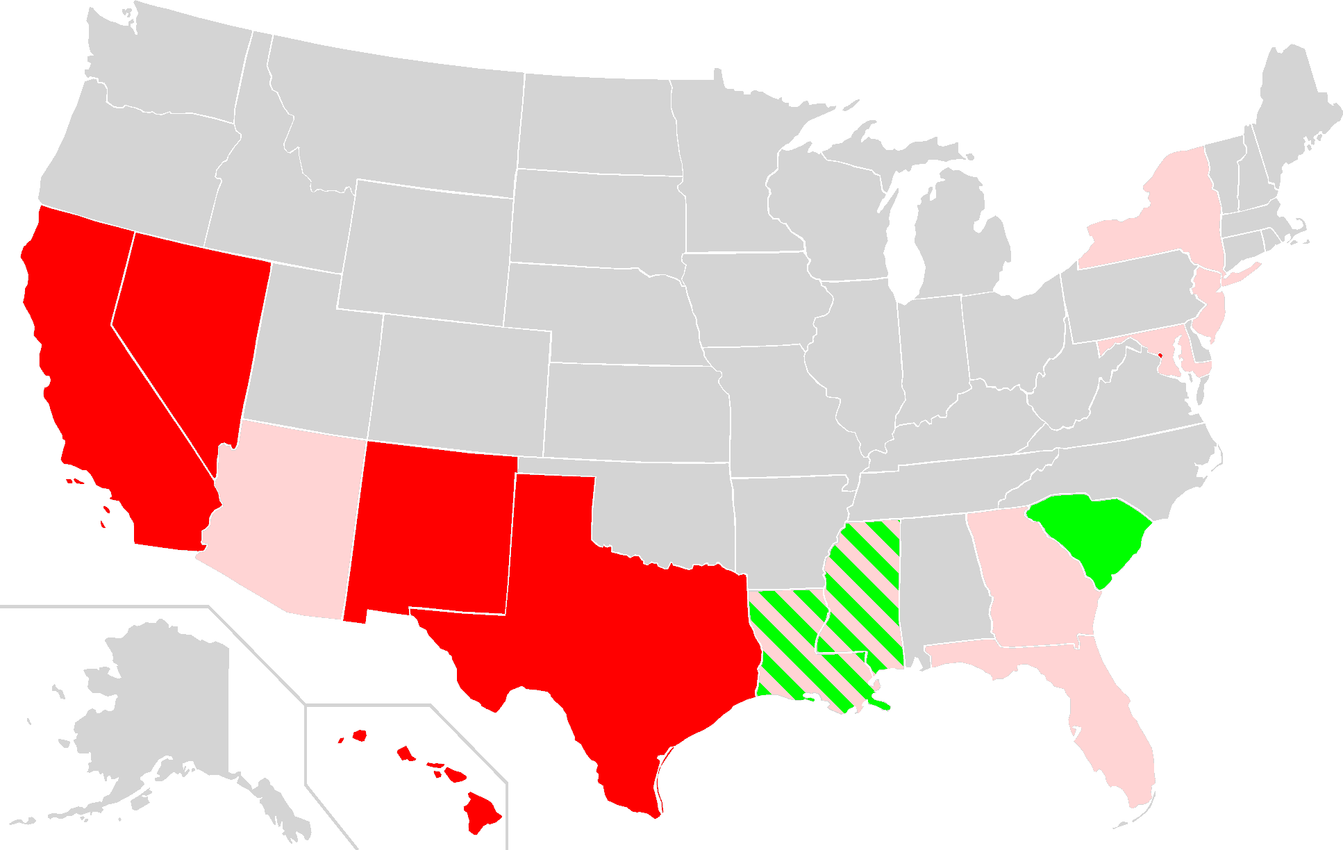
Map of USA highlighting US states and districts in which non-Hispanic whites currently are a minority or plurality (red) or were formerly a minority or plurality (green). States where non-Hispanic whites are currently less than 60% of the population are colored in pink. For more info see en:Majority-minority state. Current majority-minority states
Former majority-minority states
States where non-Hispanic whites are currently less than 60% |
|||
| Date | (UTC) | |||
| Source |
This file was derived from: Map of USA highlighting european minority.svg: |
|||
| Author |
|
|||
| Other versions |
|


| This is a retouched picture, which means that it has been digitally altered from its original version. Modifications: Added green coloring to former majority-minority states. The original can be viewed here: Map of USA highlighting european minority.svg:
|
Licensing
I, the copyright holder of this work, hereby publish it under the following license:
This file is licensed under the Creative Commons Attribution-Share Alike 2.5 Generic license.
- You are free:
- to share – to copy, distribute and transmit the work
- to remix – to adapt the work
- Under the following conditions:
- attribution – You must give appropriate credit, provide a link to the license, and indicate if changes were made. You may do so in any reasonable manner, but not in any way that suggests the licensor endorses you or your use.
- share alike – If you remix, transform, or build upon the material, you must distribute your contributions under the same or compatible license as the original.
Original upload log
This image is a derivative work of the following images:
- File:Map_of_USA_highlighting_european_minority.svg licensed with Cc-by-sa-2.5
- 2012-11-09T02:37:51Z Futurist110 2000x1237 (328519 Bytes) Added green coloring for former majority-minority states.
- 2007-07-07T23:19:41Z Lokal Profil 959x593 (80283 Bytes) {{Information |Description=Map of USA highlighting US states and districts in which non-Hispanic whites are a minority. For more info see [[:en:Majority-minority state]] |Source=*Vector map from [[:Image:Blank US Map.svg]] by
Uploaded with derivativeFX
File history
Click on a date/time to view the file as it appeared at that time.
| Date/Time | Thumbnail | Dimensions | User | Comment | |
|---|---|---|---|---|---|
| current | 12:51, 26 May 2025 | | 1,934 × 1,224 (118 KB) | Oratas | Non-Hispanic whites are now less than 60% in Alaska. |
File usage
The following page uses this file: