File:Samoa islands 2002.gif
From WikiMD's medical encyclopedia
No higher resolution available.
Samoa_islands_2002.gif (710 × 418 pixels, file size: 46 KB, MIME type: image/gif)

|
This map image could be re-created using vector graphics as an SVG file. This has several advantages; see Commons:Media for cleanup for more information. If an SVG form of this image is available, please upload it and afterwards replace this template with
{{vector version available|new image name}}.It is recommended to name the SVG file “Samoa islands 2002.svg”—then the template Vector version available (or Vva) does not need the new image name parameter. |
Summary
| Description |
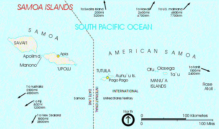
English: A map of the Samoa Islands |
| Date | Unknown date |
| Source |
US National Park Service Identical image available from:
|
| Author | From US National Park Service circa 2002 |
Licensing
| This image or media file contains material based on a work of a National Park Service employee, created as part of that person's official duties. As a work of the U.S. federal government, such work is in the public domain in the United States. See the NPS website and NPS copyright policy for more information. |
Original upload log
| date/time | username | resolution | size | edit summary |
|---|---|---|---|---|
| 01:34, 27 September 2005 | w:en:User:Dr U | 709×418 | 14 KB | From US National Park Service circa 2002 |
Image description page history
File history
Click on a date/time to view the file as it appeared at that time.
| Date/Time | Thumbnail | Dimensions | User | Comment | |
|---|---|---|---|---|---|
| current | 15:40, 18 October 2020 | | 710 × 418 (46 KB) | Foghe | Border. |
File usage
The following page uses this file: