File:Parishes of Montserrat.svg
From WikiMD's medical encyclopedia

Size of this PNG preview of this SVG file: 264 × 401 pixels. Other resolutions: 158 × 240 pixels | 316 × 480 pixels | 395 × 600 pixels | 505 × 768 pixels | 674 × 1,024 pixels | 1,348 × 2,048 pixels.
Original file (SVG file, nominally 264 × 401 pixels, file size: 7 KB)
Summary
| Description |
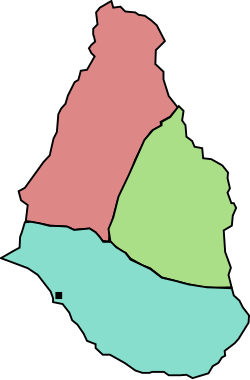
English: A map of the three parishes of the island of Montserrat. Saint Peter is shown in pale red, Saint Georges in green and Saint Anthony in blue. The black square marks Plymouth, the island's capital. Based on http://www.statoids.com/mms.html, however, map data is not detailed enough to have copyright implications. |
| Date | |
| Source | Own work |
| Author | Jarry1250 |
| Other versions | Derivative works of this file: Montserrat location map.svg |
| SVG development |
Licensing
| I, the copyright holder of this work, release this work into the public domain. This applies worldwide. In some countries this may not be legally possible; if so: I grant anyone the right to use this work for any purpose, without any conditions, unless such conditions are required by law. |
File history
Click on a date/time to view the file as it appeared at that time.
| Date/Time | Thumbnail | Dimensions | User | Comment | |
|---|---|---|---|---|---|
| current | 19:42, 26 October 2009 | | 264 × 401 (7 KB) | Jarry1250 | {{Information |Description={{en|1=A map of the three parishes of the island of w:Montserrat. Saint Peter is shown in pale red, Saint Georges in green and Saint Anthony in blue. The black square marks Plymouth, the island's |
File usage
The following page uses this file: