File:Joyita planned route map.png
From WikiMD's medical encyclopedia
No higher resolution available.
Joyita_planned_route_map.png (755 × 587 pixels, file size: 46 KB, MIME type: image/png)
Summary
| Description |
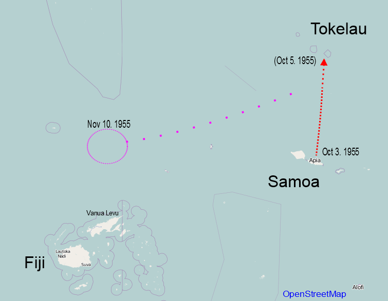
English: the planned route of MV Joyita and where it was found |
| Date | |
| Source | Own work, based on OpenStreetMap |
| Author | RicHard-59 |
Licensing
I, the copyright holder of this work, hereby publish it under the following license:
This file is licensed under the Creative Commons Attribution-Share Alike 3.0 Unported license.
- You are free:
- to share – to copy, distribute and transmit the work
- to remix – to adapt the work
- Under the following conditions:
- attribution – You must give appropriate credit, provide a link to the license, and indicate if changes were made. You may do so in any reasonable manner, but not in any way that suggests the licensor endorses you or your use.
- share alike – If you remix, transform, or build upon the material, you must distribute your contributions under the same or compatible license as the original.
File history
Click on a date/time to view the file as it appeared at that time.
| Date/Time | Thumbnail | Dimensions | User | Comment | |
|---|---|---|---|---|---|
| current | 18:19, 3 October 2013 | | 755 × 587 (46 KB) | RicHard-59 | User created page with UploadWizard |
File usage
The following page uses this file: