File:Hundred Years War 1429 copy.jpg
From WikiMD's medical encyclopedia

Size of this preview: 491 × 599 pixels. Other resolutions: 197 × 240 pixels | 393 × 480 pixels | 492 × 600 pixels | 629 × 768 pixels | 839 × 1,024 pixels | 1,670 × 2,038 pixels.
Original file (1,670 × 2,038 pixels, file size: 1.21 MB, MIME type: image/jpeg)

|
File:Hundred Years War 1429 copy.svg is a vector version of this file. It should be used in place of this JPG file when not inferior.
File:Hundred Years War 1429 copy.jpg → File:Hundred Years War 1429 copy.svg
For more information, see Help:SVG. |
 |
.
Summary
| Description |
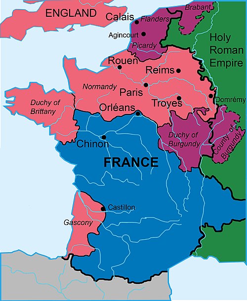
English: File shows the approximate areas controlled by the French, Burgundian and English forces in France, 1429.
Colors were design to conform to w:MOS:COLOR suggestions to increase readability for people who are visually impaired: The color set used is the vibrant schema from Paul Tol's notes linked from Wikipedia's MOS:COLOR site. File contrast was tested for color blindness using Coblis Color-blindness Simulator, which was also recommended by the WP:MOS color site. |
| Date | |
| Source |
Own work based on: Treaty of Troyes.svg by Aliesin References: Information on the map was simplified, boundaries, and other map images modified according to the map in Barker, Juliet (2009) Conquest: The English Kingdom of France, 1417-1450, Little, Brown, p. xvii ISBN: 9781408702468. OCLC: 903613803. , which shows the situation in 1492. |
| Author | Wtfiv |
Licensing
I, the copyright holder of this work, hereby publish it under the following license:
This file is licensed under the Creative Commons Attribution-Share Alike 4.0 International license.
- You are free:
- to share – to copy, distribute and transmit the work
- to remix – to adapt the work
- Under the following conditions:
- attribution – You must give appropriate credit, provide a link to the license, and indicate if changes were made. You may do so in any reasonable manner, but not in any way that suggests the licensor endorses you or your use.
- share alike – If you remix, transform, or build upon the material, you must distribute your contributions under the same or compatible license as the original.
File history
Click on a date/time to view the file as it appeared at that time.
| Date/Time | Thumbnail | Dimensions | User | Comment | |
|---|---|---|---|---|---|
| current | 04:34, 30 August 2022 | | 1,670 × 2,038 (1.21 MB) | Wtfiv | trying to upload fixed version |
File usage
The following page uses this file: