File:Colorado. Round up on the Cimarron.jpg
From WikiMD's medical encyclopedia

Size of this preview: 800 × 598 pixels. Other resolutions: 320 × 239 pixels | 640 × 479 pixels | 1,024 × 766 pixels | 1,280 × 957 pixels | 2,560 × 1,914 pixels | 7,200 × 5,384 pixels.
Original file (7,200 × 5,384 pixels, file size: 17.73 MB, MIME type: image/jpeg)
| Description |
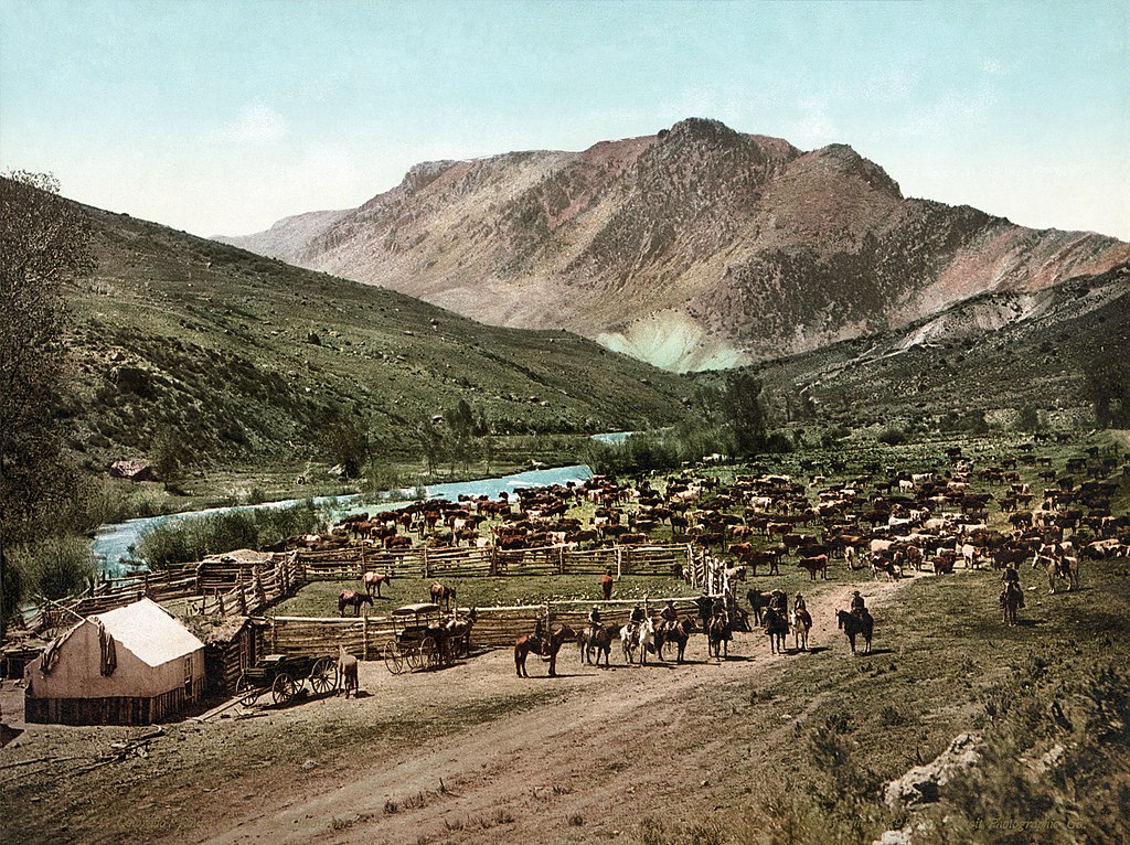
 العربية: تجميع الماشية على نهر السيمارون في كولورادو، نسخة مُلوَّنة عن صورة بيضاء وسوداء تعود لِحوالي سنة 1898، وهي تُظهر إحدى العمليَّات الكُبرى لِتجميع الماشية بِالطُرق القديمة قبل اللجوء إلى الأسلاك الشائكة، والأسوار، وغيرها من طُرق التجميع التي سهَّلت على البشر عملهم.
يغلب الظن أنَّ البلدة الظاهرة بالصورة هي سيمارون، عند المُقارنة بِالصُورة العائدة لِسنة 1883 على الجهة اليُمنى. <يقول الخبراء في مكتبة الكونغرس أنَّ النهر الظاهر على اليسار هو نهر سيمارون. هُناك عدَّة أنهر في منطقة كولورادو تحمل ذات الاسم، ولكن عند الأخذ بعين الاعتبار الجبل الظاهر والذي يسهل التعرُّف عليه، يُمكن استنتاج أنَّ هذا أحد فُرُوع نهر گانيسون.English: Colorado. "Round up" on the Cimarron, a photochrom print from c. 1898, showing one of the large musters of cattle done in the days before barbed wire, fences, and easy access to transport ended the necessity for the practice.
This is almost certainly in the town of Cimarron, compare the 1883 photograph on the right. <The LoC identify the river on the left as being the Cimarron River. There are several rivers of that name in the Colorado area, but given the very easily-identifiable mountain in this image, this would be the one that is the tributary of the Gunnison River.Français : Colorado. "Round up" on the Cimarron (Rassemblement du bétail à Cimarron), un photochrome de 1898 environ, montrant l'un des grands rassemblements de bétail qui se faisaient avant l'arrivée du fil de fer barbelé et du chemin de fer. Le lieu, Cimarron (Colorado, États-Unis), a été déduit de la comparaison avec d'autre photographies, dont celle de droite, montrant la localité à la même époque. |
||
| Date | "Copyright 1898" | ||
| Source | Library of Congress | ||
| Author | William Henry Jackson (April 4, 1843 – June 30, 1942); Detroit Photographic Co. | ||
| Permission (Reusing this file) |
|
||
| Other versions |
|
| Camera location | | View this and other nearby images on: OpenStreetMap |
|---|
| Object location | | View this and other nearby images on: OpenStreetMap |
|---|
|

| Annotations | This image is annotated: View the annotations at Commons |
File history
Click on a date/time to view the file as it appeared at that time.
| Date/Time | Thumbnail | Dimensions | User | Comment | |
|---|---|---|---|---|---|
| current | 01:14, 28 August 2010 | | 7,200 × 5,384 (17.73 MB) | Adam Cuerden | Accidentally edited out a treetop. Oops! |
File usage
The following page uses this file: