File:Cold War border changes.png
From WikiMD's medical encyclopedia
No higher resolution available.
Cold_War_border_changes.png (599 × 436 pixels, file size: 18 KB, MIME type: image/png)
Summary
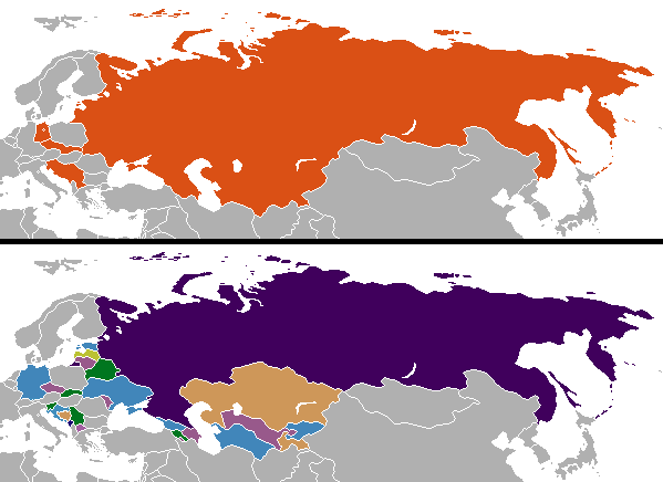
| Description |
English: Changes in internationally recognized boundaries of countries after the end of the Cold War. Orange in the "before" map represents the territories as of 1991 which were affected. |
| Date | |
| Source | Own work |
| Author | Aivazovsky (talk) (Uploads) |
Licensing
| This work has been released into the public domain by its author, Aivazovsky at English Wikipedia. This applies worldwide. In some countries this may not be legally possible; if so: Aivazovsky grants anyone the right to use this work for any purpose, without any conditions, unless such conditions are required by law. |
Colored by User:Aivazovsky from public domain Wikimedia Commons source.
Original upload log
The original description page was here. All following user names refer to en.wikipedia.
| Date/Time | Dimensions | User | Comment |
|---|---|---|---|
| 2009-12-11 10:57 | 599×436× (15723 bytes) | Ithanyx | Switched to most up-to-date template version. |
| 2008-07-19 07:01 | 599×436× (15610 bytes) | Hoshie | added the last change of the cold war: Kosovo |
| 2007-09-24 04:24 | 599×436× (20607 bytes) | Hoshie | fixed shading on two islands west of the Estonian SSR |
| 2007-02-27 02:21 | 599×436× (15749 bytes) | Aivazovsky | |
| 2006-10-10 06:35 | 599×436× (17502 bytes) | Hoshie | I have updated the map to include Montenegro, the last nation formed out of the cold war. |
| 2006-04-13 01:44 | 602×373× (14138 bytes) | Aivazovsky |
File history
Click on a date/time to view the file as it appeared at that time.
| Date/Time | Thumbnail | Dimensions | User | Comment | |
|---|---|---|---|---|---|
| current | 21:38, 21 January 2025 | | 599 × 436 (18 KB) | GPinkerton | Reverted to version as of 20:15, 17 October 2022 (UTC) Restoring internationally recognized borders |
File usage
The following 2 pages use this file: