File:Aridity ice age vs early holocene vs modern.jpg
From WikiMD's medical encyclopedia
Size of this preview: 336 × 599 pixels. Other resolutions: 135 × 240 pixels | 558 × 994 pixels.
Original file (558 × 994 pixels, file size: 365 KB, MIME type: image/jpeg)

|
This map image could be re-created using vector graphics as an SVG file. This has several advantages; see Commons:Media for cleanup for more information. If an SVG form of this image is available, please upload it and afterwards replace this template with
{{vector version available|new image name}}.It is recommended to name the SVG file “Aridity ice age vs early holocene vs modern.svg”—then the template Vector version available (or Vva) does not need the new image name parameter. |


| Description |
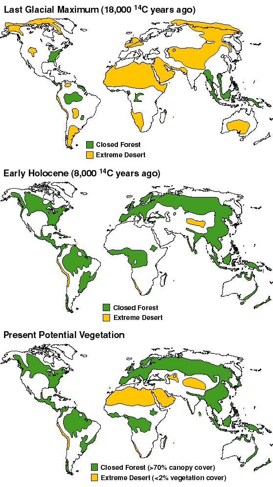
English: During the Last Glacial Maximum 14000 years ago, thermal-driven evaporation from the oceans onto continental landmasses was low, causing large areas of extreme desert, including polar deserts (cold but with low rates of precipitation). Greater precipitation today creates a much different distribution of climatic zones, although anthropogenic changes including agriculture prevent forest cover from reaching its theoretical potential. Near the start of the Atlantic Period, 8000 years ago, the world's climate was warmer and wetter than today according to an ORNL estimate. |
|||
| Date | ||||
| Source | Adams J.M. & Faure H. (1997) (eds.), QEN members. Review and Atlas of Palaeovegetation: Preliminary land ecosystem maps of the world since the Last Glacial Maximum. Oak Ridge National Laboratory, TN, USA. | |||
| Author | Oak Ridge National Laboratory. Adams J.M. & Faure H. | |||
| Permission (Reusing this file) |
Not copyrighted as stated at http://www.esd.ornl.gov/projects/qen/nerc.html
|

File history
Click on a date/time to view the file as it appeared at that time.
| Date/Time | Thumbnail | Dimensions | User | Comment | |
|---|---|---|---|---|---|
| current | 07:03, 31 May 2011 | | 558 × 994 (365 KB) | Sokavik | {{Information |Description ={{en|1=During the Last Glacial Maximum 14000 years ago, thermal-driven evaporation from the oceans onto continental landmasses was low, causing large areas of extreme desert, including polar deserts (cold but with low rates |
File usage
The following page uses this file: