File:Aerial view Loos-Hulluch trench system July 1917.jpg
From WikiMD's medical encyclopedia

Size of this preview: 516 × 599 pixels. Other resolutions: 207 × 240 pixels | 413 × 480 pixels | 517 × 600 pixels | 661 × 768 pixels | 882 × 1,024 pixels | 1,432 × 1,663 pixels.
Original file (1,432 × 1,663 pixels, file size: 1.01 MB, MIME type: image/jpeg)
| Description |
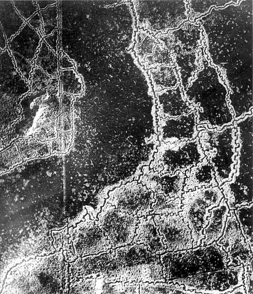
English: An aerial reconnaissance photograph of the opposing trenches and no-man's land between Loos-en-Gohelle and Hulluch in Artois, France, taken at 7.15 pm, 22 July 1917. German trenches are at the right and bottom, British trenches are at the top left. The vertical line to the left of centre indicates the course of a pre-war road or track.
The location is Hill 70, attacked and taken between 15 and 25 August 1917 by the Canadian Corps. Français : Photographie de reconnaissance aérienne des tranchées adverses et du no-man's-land qui les sépare. Les tranchées allemandes sont en bas à droite, les tranchées à gauches sont anglaises. La ligne verticale sur la gauche est tout ce qui reste d'une route. Photo prise entre Loos et Hulluch, en Artois (France) à 19h15, le 22 juillet 1917.
Русский: Аэрофотосъемка траншей (окопов) и ходов сообщения противников и разделяющей их ничейной земли, Западноевропейский театр войны. Справа внизу немецкие окопы, слева — английские, канадские. Вертикальная линия слева — это всё, что осталось от дороги. Аэроснимок сделан между Лоосом и Хюлухом, в Артуа (Франция) в 19.15, 22 июля 1917 года. |
|||
| Date | ||||
| Source |
|
|||
| Author | Unknown author | |||
| Permission (Reusing this file) |
|


| Camera location | | View this and other nearby images on: OpenStreetMap |
|---|
Note: Location is approximate.

|
This image has been assessed under the valued image criteria and is considered the most valued image on Commons within the scope: World War I trench systems, aerial view. You can see its nomination here. |
File history
Click on a date/time to view the file as it appeared at that time.
| Date/Time | Thumbnail | Dimensions | User | Comment | |
|---|---|---|---|---|---|
| current | 15:15, 13 February 2025 | | 1,432 × 1,663 (1.01 MB) | Ich | match prior crop |
File usage
The following page uses this file: