Qinghai: Difference between revisions
CSV import |
CSV import |
||
| Line 25: | Line 25: | ||
{{China-stub}} | {{China-stub}} | ||
<gallery> | |||
File:Khoshut Khanate.png|Khoshut Khanate | |||
File:Chiang Kai-shek on right Ma Buqing on left Ma Bufang second from left.png|Chiang Kai-shek with Ma Buqing and Ma Bufang | |||
File:Nianbaoyuze Geopark 2015.jpeg|Nianbaoyuze Geopark | |||
File:青海日月山 - panoramio - Tiger@西北 (3).jpg|Qinghai Riyue Mountain | |||
File:Koppen-Geiger Map v2 CHN Qinghai 1991–2020.svg|Köppen-Geiger Climate Map of Qinghai | |||
File:Dongguan mosque.jpg|Dongguan Mosque | |||
File:Qinghai.fenghuangshan.jpg|Qinghai Fenghuang Mountain | |||
File:Qinghai.Riyue shan.jpg|Qinghai Riyue Mountain | |||
File:Qinghai.Huangyuan xian mosques.jpg|Huangyuan County Mosques | |||
File:Rebkong monastery.JPG|Rebkong Monastery | |||
File:Qinghai.Duoba great mosquee.2.jpg|Duoba Great Mosque | |||
File:Oil well in Tsaidam.jpg|Oil Well in Tsaidam | |||
</gallery> | |||
Latest revision as of 01:11, 20 February 2025


Qinghai is a province located in the northwest part of the People's Republic of China. Known for its vast highland landscapes, it is part of the larger Qinghai-Tibet Plateau, which is often referred to as the "Roof of the World" due to its high altitude. Qinghai is bordered by Gansu to the northeast, Sichuan to the southeast, the Tibet Autonomous Region to the south, and Xinjiang to the northwest. The province's name, Qinghai, is derived from the largest lake in China, Qinghai Lake, a saline lake situated in the province's northeastern part.
Geography[edit]
Qinghai's geography is characterized by its high altitude and rugged terrain. The province encompasses parts of the Kunlun Mountains, which stretch across its northern border, and the Tanggula Mountains in the south. The Yellow River, China's second-longest river, originates in the eastern part of Qinghai. The region's climate varies significantly, ranging from cold arid in the western part to subarctic in the northern mountains.
History[edit]
The history of Qinghai is marked by the presence of various ethnic groups, including the Tibetans, Han Chinese, Hui, and Mongols. Historically, it was a contested region between the Tibetan Empire and the Chinese dynasties. In the early 18th century, during the Qing dynasty, the area was formally incorporated into China. Throughout its history, Qinghai has been an important site for Buddhism in China, with numerous monasteries and temples, particularly of the Tibetan Buddhist tradition.
Economy[edit]
Qinghai's economy is primarily based on agriculture, livestock, and mining. The province is rich in minerals, including salt, potassium, magnesium, and lithium, some of which are extracted from the area around Qinghai Lake. In recent years, the government has invested in developing renewable energy sources, particularly solar and wind power, leveraging the province's vast open spaces and high altitude.
Culture[edit]
The culture of Qinghai is a blend of various ethnic traditions, with a significant influence from Tibetan culture. This is evident in the province's religious practices, festivals, and cuisine. The Yushu Horse Festival and the Tibetan New Year are among the most significant cultural events celebrated in Qinghai.
Tourism[edit]
Qinghai is a popular destination for tourists seeking to experience its natural beauty and unique culture. Key attractions include Qinghai Lake, the largest lake in China; the Ta'er Monastery, an important center for Tibetan Buddhism; and the Qaidam Basin, known for its landscapes and wildlife. The province's vast, unspoiled natural environments offer opportunities for hiking, bird watching, and exploring remote Tibetan villages.
Administrative Divisions[edit]
Qinghai is divided into eight prefecture-level divisions: one prefecture-level city (Xining, the capital) and seven autonomous prefectures that are home to various ethnic minorities. These divisions are further subdivided into counties and county-level cities.
Environmental Concerns[edit]
Qinghai faces several environmental challenges, including desertification, melting glaciers, and the degradation of Qinghai Lake due to climate change and human activities. Efforts are being made to address these issues through conservation projects and the promotion of sustainable development practices.

-
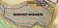 Khoshut Khanate
 -
 Chiang Kai-shek with Ma Buqing and Ma Bufang
 -
 Nianbaoyuze Geopark
 -
 Qinghai Riyue Mountain
 -
 Köppen-Geiger Climate Map of Qinghai
 -
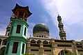 Dongguan Mosque
 -
 Qinghai Fenghuang Mountain
 -
 Qinghai Riyue Mountain
 -
 Huangyuan County Mosques
 -
 Rebkong Monastery
 -
 Duoba Great Mosque
 -
 Oil Well in Tsaidam


.jpg)


