Arrhenius equation: Difference between revisions
CSV import |
CSV import Tags: mobile edit mobile web edit |
||
| Line 1: | Line 1: | ||
{{short description|Web mapping service by Apple}} | |||
{{Use mdy dates|date=October 2023}} | |||
'''Apple Maps''' is a [[web mapping]] service developed by [[Apple Inc.]], providing directions and estimated times of arrival for driving, walking, cycling, and public transportation navigation. It was first released in 2012 as a part of [[iOS 6]], replacing [[Google Maps]] as the default map service on Apple devices. | |||
==History== | |||
Apple Maps was announced at the [[Apple Worldwide Developers Conference]] (WWDC) in June 2012. The initial release was met with criticism due to inaccuracies and lack of features compared to competitors. Over the years, Apple has made significant improvements, including the introduction of [[Flyover (Apple Maps)|Flyover]], [[turn-by-turn navigation]], and [[public transit]] directions. | |||
==Features== | |||
Apple Maps offers a variety of features designed to enhance the user experience: | |||
* '''Turn-by-turn navigation''': Provides spoken directions and visual cues for drivers, cyclists, and pedestrians. | |||
* '''Flyover''': A 3D view of major cities, allowing users to explore landmarks from an aerial perspective. | |||
* '''Public transit''': Offers detailed transit directions, including schedules and route maps for buses, trains, and subways. | |||
* '''Indoor maps''': Available for airports and shopping malls, providing detailed floor plans and navigation within large venues. | |||
* '''Look Around''': A street-level imagery feature similar to [[Google Street View]], available in select locations. | |||
== | ==Data Collection and Privacy== | ||
Apple Maps collects data from various sources, including satellite imagery, public transit information, and user feedback. Apple emphasizes user privacy, stating that data is anonymized and not linked to individual users. The service also uses on-device processing to minimize data sent to Apple's servers. | |||
== | ==Market Share and Competition== | ||
Apple Maps competes with other mapping services such as [[Google Maps]], [[Waze]], and [[Bing Maps]]. While initially criticized, Apple Maps has gained market share over the years, particularly among iOS users. The integration with Apple's ecosystem, including [[Siri]] and [[CarPlay]], has contributed to its growing popularity. | |||
== | ==Recent Developments== | ||
In recent years, Apple has focused on expanding the coverage and accuracy of Apple Maps. The company has deployed mapping vehicles to collect data and improve the service's detail and precision. New features, such as native ratings and photos support, have been added to enhance user interaction and provide more comprehensive information. | |||
== | ==Gallery== | ||
<gallery> | |||
File:Apple Maps logo.svg|Apple Maps logo | |||
File:WWDC 2012 Interior.jpg|WWDC 2012, where Apple Maps was announced | |||
File:Apple Maps Car April 2023.jpg|Apple Maps data collection vehicle | |||
File:Apple Maps directions interface.png|Apple Maps directions interface | |||
File:Apple Maps Native Ratings and Photos Support (As of 02-2024).png|Native ratings and photos support | |||
File:Market share Apple Maps and Google Maps.png|Market share comparison between Apple Maps and Google Maps | |||
</gallery> | |||
[[Category: | ==Related pages== | ||
[[Category: | * [[Google Maps]] | ||
* [[Waze]] | |||
* [[Bing Maps]] | |||
* [[OpenStreetMap]] | |||
[[Category:Apple Inc. software]] | |||
[[Category:Web mapping]] | |||
[[Category:IOS software]] | |||
[[Category:2012 software]] | |||
Revision as of 18:06, 11 February 2025
Web mapping service by Apple
Apple Maps is a web mapping service developed by Apple Inc., providing directions and estimated times of arrival for driving, walking, cycling, and public transportation navigation. It was first released in 2012 as a part of iOS 6, replacing Google Maps as the default map service on Apple devices.
History
Apple Maps was announced at the Apple Worldwide Developers Conference (WWDC) in June 2012. The initial release was met with criticism due to inaccuracies and lack of features compared to competitors. Over the years, Apple has made significant improvements, including the introduction of Flyover, turn-by-turn navigation, and public transit directions.
Features
Apple Maps offers a variety of features designed to enhance the user experience:
- Turn-by-turn navigation: Provides spoken directions and visual cues for drivers, cyclists, and pedestrians.
- Flyover: A 3D view of major cities, allowing users to explore landmarks from an aerial perspective.
- Public transit: Offers detailed transit directions, including schedules and route maps for buses, trains, and subways.
- Indoor maps: Available for airports and shopping malls, providing detailed floor plans and navigation within large venues.
- Look Around: A street-level imagery feature similar to Google Street View, available in select locations.
Data Collection and Privacy
Apple Maps collects data from various sources, including satellite imagery, public transit information, and user feedback. Apple emphasizes user privacy, stating that data is anonymized and not linked to individual users. The service also uses on-device processing to minimize data sent to Apple's servers.
Apple Maps competes with other mapping services such as Google Maps, Waze, and Bing Maps. While initially criticized, Apple Maps has gained market share over the years, particularly among iOS users. The integration with Apple's ecosystem, including Siri and CarPlay, has contributed to its growing popularity.
Recent Developments
In recent years, Apple has focused on expanding the coverage and accuracy of Apple Maps. The company has deployed mapping vehicles to collect data and improve the service's detail and precision. New features, such as native ratings and photos support, have been added to enhance user interaction and provide more comprehensive information.
Gallery
-
 Apple Maps logo
 -
 WWDC 2012, where Apple Maps was announced
 -
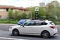 Apple Maps data collection vehicle
 -
Apple Maps directions interface
-
 Native ratings and photos support
 -
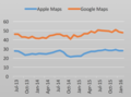 Market share comparison between Apple Maps and Google Maps


.png)

