Rotterdam: Difference between revisions
CSV import Tags: mobile edit mobile web edit |
CSV import |
||
| Line 26: | Line 26: | ||
[[Category:Port cities and towns in the Netherlands]] | [[Category:Port cities and towns in the Netherlands]] | ||
[[Category:Rotterdam]] | [[Category:Rotterdam]] | ||
<gallery> | |||
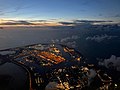
File:A_view_of_Rotterdam,_taken_from_the_roof_of_the_Maassilo,_Rotterdam,_The_Netherlands.jpg|A view of Rotterdam, taken from the roof of the Maassilo, Rotterdam, The Netherlands | |||
File:Laurenskerk,_Rotterdam.jpg|Laurenskerk, Rotterdam | |||
File:Rotterdam_zadkine_monument.jpg|Rotterdam zadkine monument | |||
File:Rotterdam_euromast.jpg|Rotterdam euromast | |||
File:Rotterdam_-_Cube_houses.jpg|Rotterdam - Cube houses | |||
File:Rotterdam_feyenoord_stadion_1.jpg|Rotterdam feyenoord stadion 1 | |||
File:Rotterdam-Delfshaven,_havenzicht1_foto12_2011-01-09_12.51.JPG|Rotterdam-Delfshaven, havenzicht1 foto12 2011-01-09 12.51 | |||
File:Maasvlakte-22OKT2022-1.jpg|Maasvlakte-22OKT2022-1 | |||
File:Rotterdam_Map_by_Frederick_De_Wit_c1690.jpg|Rotterdam Map by Frederick De Wit c1690 | |||
File:Detroit_Publishing_Company_-_Rotterdam_-_Delftsevaart,_c._1895.jpg|Detroit Publishing Company - Rotterdam - Delftsevaart, c. 1895 | |||
File:Standbeeld_Maagd_van_Nederland,_Nieuwe_Markt,_Rotterdam,_1915.jpg|Standbeeld Maagd van Nederland, Nieuwe Markt, Rotterdam, 1915 | |||
File:Rotterdam,_Laurenskerk,_na_bombardement_van_mei_1940.jpg|Rotterdam, Laurenskerk, na bombardement van mei 1940 | |||
</gallery> | |||
Latest revision as of 21:05, 23 February 2025
Rotterdam is the second-largest city in the Netherlands, and one of the largest ports in the world. It is located in the province of South Holland, near the mouth of the Nieuwe Maas channel leading into the Rhine–Meuse–Scheldt delta at the North Sea. Its history goes back to 1270, when a dam was constructed in the Rotte river, after which people settled around it for safety. In 1340, Rotterdam was granted city rights by the Count of Holland.
History[edit]
Rotterdam's early history is tied to the rise of the Dutch Empire. In the 17th century, it became a hub for international trade, a period known as the Dutch Golden Age. The city was heavily bombed during World War II, in an event known as the Rotterdam Blitz, which led to its modern architectural landscape.
Economy[edit]
Rotterdam's economy is heavily influenced by its strategic location and its port, the Port of Rotterdam, which is the busiest port in Europe and the 10th busiest in the world. The city is also a major logistic and economic centre, with industries such as shipping, logistics, and petrochemicals playing a significant role.
Culture[edit]
Rotterdam is known for its Erasmus University, its cultural life, its maritime heritage and its modern architecture. The city is home to several major cultural institutions, including the Museum Boijmans Van Beuningen, the Netherlands Architecture Institute, and the Rotterdam Philharmonic Orchestra.
Transport[edit]
Rotterdam is well connected by international, national and regional transport systems. The city has its own airport, Rotterdam The Hague Airport, and a comprehensive public transport network including trams, buses, and the Rotterdam Metro.
See also[edit]
- History of Rotterdam
- Architecture of Rotterdam
- Culture of Rotterdam
- Economy of Rotterdam
- Transport in Rotterdam

This article is a Netherlands location stub. You can help WikiMD by expanding it!

-
 A view of Rotterdam, taken from the roof of the Maassilo, Rotterdam, The Netherlands
 -
 Laurenskerk, Rotterdam
 -
 Rotterdam zadkine monument
 -
 Rotterdam euromast
 -
 Rotterdam - Cube houses
 -
 Rotterdam feyenoord stadion 1
 -
 Rotterdam-Delfshaven, havenzicht1 foto12 2011-01-09 12.51
 -
 Maasvlakte-22OKT2022-1
 -
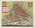 Rotterdam Map by Frederick De Wit c1690
 -
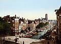 Detroit Publishing Company - Rotterdam - Delftsevaart, c. 1895
 -
 Standbeeld Maagd van Nederland, Nieuwe Markt, Rotterdam, 1915
 -
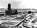 Rotterdam, Laurenskerk, na bombardement van mei 1940


