Cold-core low: Difference between revisions
CSV import Tags: mobile edit mobile web edit |
CSV import Tags: mobile edit mobile web edit |
||
| Line 29: | Line 29: | ||
{{Meteorology-stub}} | {{Meteorology-stub}} | ||
== Cold-core_low == | |||
<gallery> | |||
File:TUTTcellWestPac2007071012WV.jpg|Tropical Upper Tropospheric Trough cell in the Western Pacific | |||
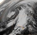
File:Upper_Level_Low_Jul_20_2012.jpg|Upper Level Low on July 20, 2012 | |||
File:Thermal_wind.jpg|Illustration of Thermal Wind | |||
File:KonaLowNovember041995IR.jpg|Kona Low on November 4, 1995 | |||
File:WorldwideTCpeaks.gif|Worldwide Tropical Cyclone Peaks | |||
</gallery> | |||
Latest revision as of 04:36, 18 February 2025
Cold-core low, also known as an upper-level cold low or cold-core cyclone, is a type of atmospheric circulation characterized by a low-pressure area surrounded by a cold temperature anomaly at higher altitudes in the atmosphere. Unlike their warm-core counterparts, which are typically associated with tropical cyclones, cold-core lows are more common in mid to high latitudes and can lead to various weather phenomena, including heavy rainfall, snow, and thunderstorms.
Characteristics[edit]
Cold-core lows form primarily in the upper atmosphere, typically within the troposphere, the lowest layer of the Earth's atmosphere where most weather occurs. They are distinguished by a center of low pressure surrounded by cooler air, which is in contrast to the surrounding air masses. This temperature difference is due to the cold air aloft, which makes the system unstable and can lead to convective activity, including the development of clouds and precipitation.
One of the key features of a cold-core low is its ability to persist for extended periods, often several days, without significant movement. This is partly because they are steered by the upper-level atmospheric flow and are less influenced by surface features such as landmasses and bodies of water.
Development and Dissipation[edit]
The development of a cold-core low often begins with a disturbance in the upper-level flow, such as a trough or a cut-off low from a larger weather system. As the system becomes more isolated, it can intensify into a cold-core low through processes such as diabatic cooling, which occurs due to the emission of longwave radiation, or through dynamic processes like the stretching of vorticity columns in the atmosphere.
Dissipation of a cold-core low typically occurs when the system moves over warmer surfaces, which can destabilize the low by warming the air at the lower levels, or when it encounters a stronger weather system that absorbs or disrupts the cold-core low's circulation.
Impact[edit]
Cold-core lows can have significant impacts on weather and climate. They are often associated with unstable weather conditions, including heavy precipitation, thunderstorms, and in some cases, snowfall. The instability and lifting mechanisms within the cold-core low can lead to the development of cumulonimbus clouds, which are capable of producing severe weather.
In addition to precipitation, cold-core lows can also lead to temperature anomalies, with cooler temperatures under the low and warmer temperatures around its periphery. This can affect agricultural practices, energy usage, and daily life, particularly in regions that are unaccustomed to such weather patterns.
Forecasting Challenges[edit]
Forecasting the development, movement, and impact of cold-core lows presents challenges to meteorologists. Their relatively isolated nature and the complex interactions between the upper and lower levels of the atmosphere make it difficult to predict their behavior using standard weather models. Forecasters must rely on a combination of satellite imagery, upper-air observations, and numerical weather prediction models to track and predict the evolution of these systems.
See Also[edit]

This article is a meteorology–related stub. You can help WikiMD by expanding it!
Cold-core_low[edit]
-
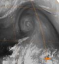 Tropical Upper Tropospheric Trough cell in the Western Pacific
 -
 Upper Level Low on July 20, 2012
 -
 Illustration of Thermal Wind
 -
 Kona Low on November 4, 1995
 -
 Worldwide Tropical Cyclone Peaks


