Guntur district: Difference between revisions
CSV import |
CSV import Tags: mobile edit mobile web edit |
||
| Line 41: | Line 41: | ||
[[Category:Districts of Andhra Pradesh]] | [[Category:Districts of Andhra Pradesh]] | ||
[[Category:Coastal districts of Andhra Pradesh]] | [[Category:Coastal districts of Andhra Pradesh]] | ||
<gallery> | |||
File:Brahmi Script inscribed on a Railing Pillar at Velpuru 02.jpg|Brahmi Script inscribed on a Railing Pillar at Velpuru | |||
File:NASA-GNT.jpg|NASA image of Guntur | |||
File:Guntur district.png|Map of Guntur district | |||
File:Tobacco Drying at Grandhasiri village.JPG|Tobacco Drying at Grandhasiri village | |||
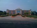
File:Hindu college in Guntur.jpg|Hindu college in Guntur | |||
File:Acharyanagarjuna3.JPG|Acharya Nagarjuna | |||
File:Ponnur Anjaneya Swamy Temple 02.jpg|Ponnur Anjaneya Swamy Temple | |||
File:Government General Hospital, Guntur.jpg|Government General Hospital, Guntur | |||
</gallery> | |||
Latest revision as of 05:28, 3 March 2025
Guntur District[edit]
Guntur district is located in the state of Andhra Pradesh, India. It is situated on the eastern coast of the country and is known for its rich cultural heritage, historical significance, and agricultural prosperity. The district is named after its administrative headquarters, Guntur city.
Geography[edit]
Guntur district is spread over an area of approximately 11,391 square kilometers. It is bordered by the Krishna district to the east, Prakasam district to the south, and Nalgonda and Khammam districts of Telangana to the west. The Bay of Bengal lies to the east of the district, providing it with a coastal stretch of about 100 kilometers.
The district is characterized by a diverse topography, with the eastern part being predominantly coastal plains, while the western part consists of hills and plateaus. The Krishna River flows through the district, dividing it into two regions - the Krishna Delta in the east and the upland region in the west.
History[edit]
Guntur district has a rich historical background, with evidence of human habitation dating back to the Neolithic era. The region has witnessed the rule of various dynasties, including the Satavahanas, Ikshvakus, Pallavas, Cholas, and Vijayanagara Empire.
During the British colonial period, Guntur district was a part of the Madras Presidency. It played a significant role in the freedom struggle of India, with many prominent leaders emerging from the region. After India gained independence in 1947, Guntur became a part of the state of Andhra Pradesh.
Economy[edit]
Agriculture is the primary occupation of the people in Guntur district. The fertile soil and favorable climatic conditions make it ideal for the cultivation of crops such as paddy, cotton, tobacco, and chillies. Guntur is known as the "Chilli Capital of India" due to its extensive production and export of chillies.
Apart from agriculture, the district also has a growing industrial sector. It is home to several industrial estates and special economic zones, attracting investments in sectors such as textiles, food processing, pharmaceuticals, and automobile components.
Tourism[edit]
Guntur district offers a range of tourist attractions for visitors. Some of the notable places to visit include:
- Amaravati - The ancient capital of the Satavahanas, known for its Buddhist heritage and the famous Amaravati Stupa.
- Undavalli Caves - A series of rock-cut caves adorned with intricate sculptures, dating back to the 4th-5th century.
- Kondaveedu Fort - A hilltop fort with ruins of ancient structures, offering panoramic views of the surrounding landscape.
- Mangalagiri - A pilgrimage site known for its ancient temple dedicated to Lord Narasimha.
- Nagarjuna Sagar Dam - One of the largest dams in India, built across the Krishna River, offering scenic views and boating facilities.
Administration[edit]
Guntur district is divided into three revenue divisions - Guntur, Tenali, and Narasaraopet. It is further divided into 57 mandals (administrative units) and 1,091 villages. The district is represented in the state legislative assembly by multiple constituencies.
Transport[edit]
Guntur district is well-connected by road, rail, and air. The National Highway 16 (NH 16) passes through the district, connecting it to major cities like Chennai and Kolkata. The Guntur Junction railway station is an important railway hub, with regular train services to various parts of the country. The nearest airport is the Vijayawada International Airport, located approximately 40 kilometers away.
References[edit]
External links[edit]
-
 Brahmi Script inscribed on a Railing Pillar at Velpuru
 -
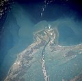 NASA image of Guntur
 -
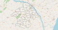 Map of Guntur district
 -
 Tobacco Drying at Grandhasiri village
 -
 Hindu college in Guntur
 -
 Acharya Nagarjuna
 -
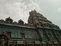 Ponnur Anjaneya Swamy Temple
 -
 Government General Hospital, Guntur


